Houston · Port Houston, the ship channel and the plants beside it

RTLS software in Houston, for the plants and shops along the ship channel

Spatial Map is the map side of a real-time locating system: it shows tags moving live on a 3D plan of the building, with the room each one is in, visit and dwell times, and the vendor’s alarms mirrored as in-app alerts. RTLS software in Houston has an obvious customer base: the Houston Ship Channel runs past what the Texas Comptroller calls the nation’s largest petrochemical complex, and every plant, fabrication shop and tool crib around it has people, tools and vehicles that have to be found.

No credit card. Runs in the browser. Pro is $60/month for up to 4 facilities. Book a demo

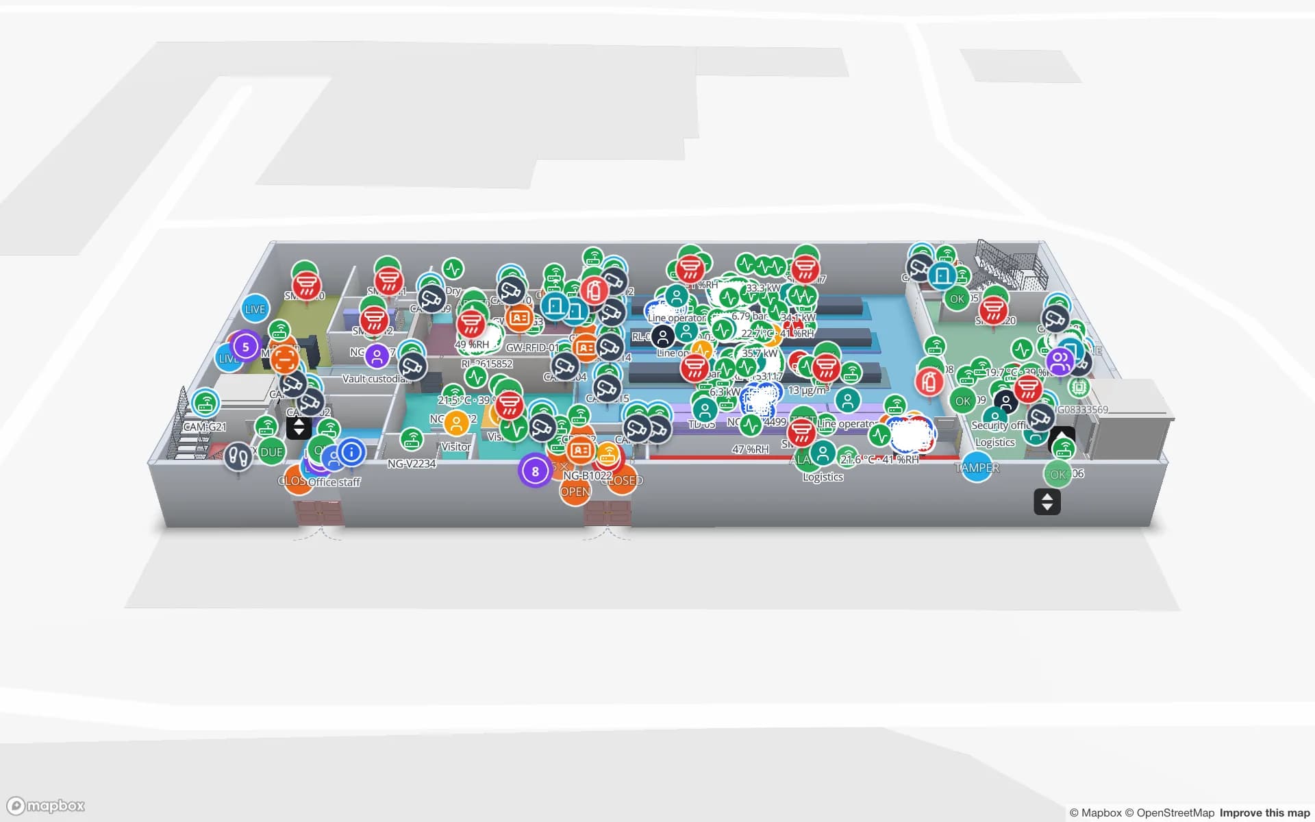
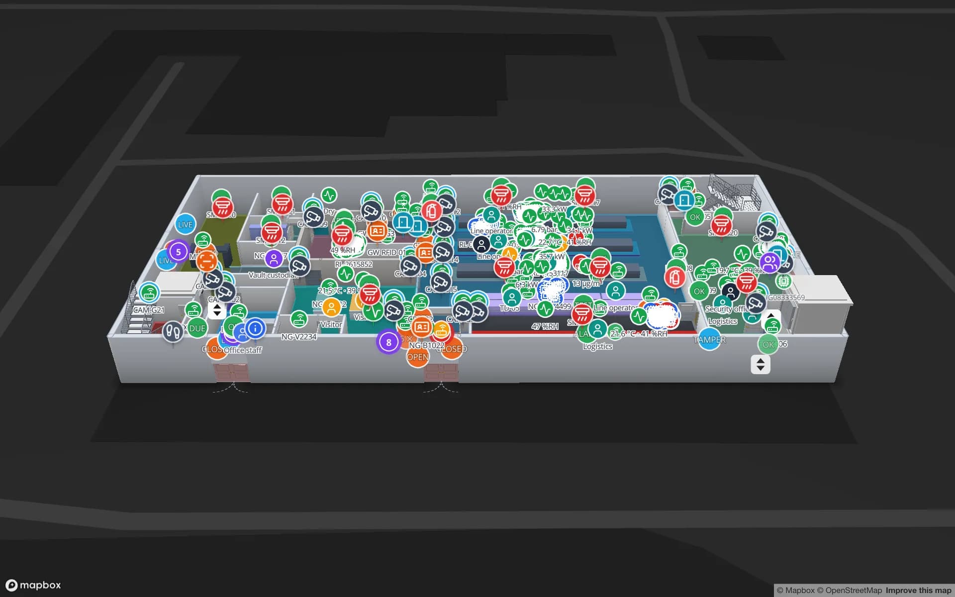
Northgate Electronics — Assembly & Secure Store, a electronics assembly & secure store demo, in the Spatial Map 3D viewer with live device markers
Northgate Electronics — Assembly & Secure Store
Northgate Electronics, a demo plant with a secure store: security zones, access points, cameras and choke-point counters over two floors.
High-value units tracked in the Northgate demo
863
How often alert rules are checked, with alerts shown in the app
15 s
Built-in RTLS driver today: BlueIOT, plus any engine through the write API
1
Free trial, up to 5 facilities, no card
7 days

Fifty-two miles of channel and the plants along it

Port Houston describes a 52-mile Houston Ship Channel with eight public facilities along it, two container terminals (Barbours Cut and Bayport) and the area’s largest breakbulk facility. The channel’s widening was completed on 7 September 1914 and its opening observed in November that year; the district traces itself to a $1.25 million bond vote by Harris County in 1911. The Texas Comptroller adds that the port includes “the nation’s largest petrochemical complex (second largest in the world)”, and about 75 percent of US waterborne plastic resin exports, from a 2016 source.

That geography decides what RTLS is for in Houston. A process plant is mostly outdoors, but a plant has many buildings: control rooms, warehouses, maintenance shops, tool cribs, laboratories and offices. Inside those buildings, tags on tools, carts, forklifts and badges are straightforward to place on a floor plan, and Spatial Map shows them. Spatial Map is indoor mapping software: it does not map open process areas, and it is not a safety system. It makes no certification claim, and it does not replace your plant’s own safety systems.


What a real-time locating system does, and what Spatial Map does with it

An RTLS has three parts: tags, fixed infrastructure such as UWB anchors or BLE gateways, and a positioning engine that turns signals into coordinates. Spatial Map is not the engine. It never computes a position from BLE signal strength itself. A BlueIOT server connects from the Integrations screen; tags then move live on the map with the room they are in, room visits and dwell, the vendor’s alarms mirrored as alerts, and auto-created tables, a layer and reports.

Other engines such as Sewio, Quuppa, Pozyx and Kontakt.io connect today by posting rows through the table write API or by REST polling. There is no MQTT driver yet. The engine can run in the cloud or through the on-site agent, a small program on a PC on the plant network that makes outbound HTTPS calls only, opens no ports, buffers to disk if the link drops and shows Online with its last heartbeat. See device connections, and BLE vs UWB vs Wi-Fi RTLS for what each technology is good for.

Contractors, tools and the shop floor

Plants and shops commonly rely on contractors for turnarounds, fabrication and maintenance, which means a crowd of tools, rental equipment and short-term badges arriving, working and leaving on a schedule. The questions are practical: which tool crib holds the torque wrench, which contractor still has the borrowed instrument, which room is holding up a job, which bay is queueing.

Tag the tools and read them at the crib door, and the map shows each tool’s last-seen room, with overdue returns colored. Tag a handful of high-value carts and forklifts with UWB or BLE, and the room-visits report shows how long each stayed in which bay. A heatmap of positions shows where traffic piles up; the heatmaps page covers how it is drawn. The Northgate demo follows 863 high-value units through security zones and choke points and is a good model for a secure tool store, and RFID tool tracking covers the crib pattern when RFID is enough and RTLS would be overkill.

Warehouses and yards on the channel

Not every Houston building is a plant. Port Houston’s container terminals feed distribution centers and cross-docks around the metro, and Project 11, the ship-channel widening, has already taken the Galveston Bay reach from 530 to 700 feet; Port Houston says it finished its portion in October 2025, with the Army Corps leading the rest through 2029. Port Houston says the widening allows two-way vessel traffic from Bolivar Roads to Morgans Point, which matters to the buildings that receive the cargo and need to know where each container goes.

For a cross-dock the first layer is not RTLS but the doors, lanes and yard slots, which the Eastport demo shows with 50 dock doors, 44 yard slots and 1,180 RFID pallets. Forklifts and yard tractors carrying a BLE or UWB tag appear as live markers on the same map. Spatial Map does not read terminal or port community systems, and it does not track vehicles outdoors on the channel or highways; yard GPS stays with your telematics.

Services for teams in Houston

Houston teams usually take RTLS in steps:

  • Most teams begin with asset tracking for tools and equipment, using RFID at the crib door, and add RTLS only for the few things that must be located between doors.
  • RTLS software and UWB become the focus where continuous positions matter: forklifts, carts and a limited number of badges in a building.
  • If you need tags and anchors, our team can source UWB anchors and tags, BLE gateways and RFID readers on request, quoted per project, with warranty and device support from the manufacturer: see hardware and demo kits on request.
  • Where an engine or ERP has no connector, our team builds relays and integrations as client projects, including Android RFID handheld apps.
  • The product runs as cloud or on-premises, including the on-site agent on a plant network that cannot open inbound ports.

Also served nearby

The same page covers Pasadena, Deer Park, La Porte, Baytown and Channelview along the channel, and Sugar Land, The Woodlands and Katy for the distribution and campus buildings around the metro.

How Spatial Map does it

From a plan to live tags

  1. 01

    Map the building

    Upload the plan or photograph, let AI Map draft walls, doors and rooms for a person to review, and name rooms like your positioning engine does.

  2. 02

    Connect the engine

    A BlueIOT server connects from Integrations, in the cloud or through the on-site agent; other engines post rows through the write API or a polled REST endpoint.

  3. 03

    Check positions against the rooms

    See each tag in its room, with visits and dwell, and replay yesterday with the History player.

  4. 04

    Add alerts

    In-app alerts for tags that go silent, items out of their zone and counts above a threshold.

Where Houston teams use RTLS

Tool cribs and secure stores

Tools, check-out and high-value stock read at the door, with positions inside the store.

Fabrication and assembly shops

Carriers, carts and WIP by bay, with dwell between stations.

Cross-docks and yards

Forklifts and tractors as live markers beside dock doors and yard slots.

Equipment and IT stores

Check-out, spares and equipment tied to the room they belong to.

See it on real demo facilities

Fictional names, real floor plans, live sensors, RFID, BLE tags and gateways — open any of them in the browser.

All 13 demo facilities

RTLS software in Houston: questions we get

No. It is mapping and tracking software, not a safety system, and it makes no safety or certification claim. Alerts are in-app only (bell, toast and the Alerts page); there is no email, SMS or push, and nothing is written back to other systems.

No. Spatial Map is indoor mapping software: it draws buildings, floors and rooms from plans. It can show a yard slot grid and a gate lane as areas on a plan, but open process areas and vehicle GPS stay with your own systems.

A BlueIOT server connects directly from the Integrations screen. Engines such as Sewio, Quuppa, Pozyx or Kontakt.io connect today by posting rows through the table write API or by REST polling. There is no MQTT driver yet, and Spatial Map never computes positions from BLE signal strength itself.

No. The on-site agent runs on any PC on the plant network, makes outbound HTTPS calls only, opens no ports, buffers to disk if the link drops and shows Online with its last heartbeat. The product can also run on-premises if your policy requires it.

No. Spatial Map is sold online and our team works with customers in the United States remotely, by video call and through the contact form. There are no local resellers or partners.

In US dollars, the same worldwide: a 7-day free trial for up to 5 facilities with no card, then Pro at $60 a month or $600 a year for up to 4 facilities. UWB and BLE hardware, if you ask us to source it, is quoted per project and is not part of the subscription.

Put one tool crib on the map first.

Start the free trial and open the Northgate demo, or send us the plan of a shop, store or warehouse and the engine you plan to use through the contact form.