Africa · Algeria

Indoor mapping & RFID tracking in Algeria

Spatial Map is browser-based software for indoor mapping & RFID tracking in Algeria: it turns the floor plan of a warehouse, a plant or a cold store into a live 3D map fed by your readers, gateways and sensors. Algerian trade is concentrated around Algiers and its port, with a dry port on the city’s edge and a second deep-water gateway at Djen Djen to the east, and the app is available in both Arabic, in a right-to-left layout, and French, so each person on a team can read the same map in their own language.

No credit card. Runs in the browser. Pro is $60/month for up to 4 facilities. Book a demo

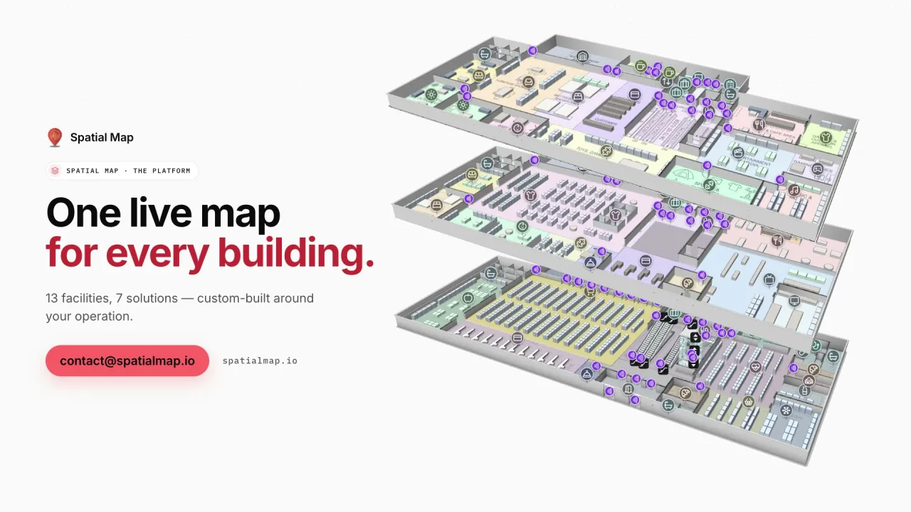
Platform film: “One live map for every building” beside three stacked floors of a demo warehouse in 3D
The Spatial Map platform film: demo facilities modelled to scale, with their devices layered over the floor plan.
RFID pallets in the Eastport cross-dock demo
1,180
Rack locations in the Summit assembly-plant demo
867
Interface languages that fit Algeria, Arabic in right-to-left layout
AR · FR
Free trial, up to 5 facilities, no credit card
7 days

The port of Algiers and the dry port at Rouiba

Three quays at the Port of Algiers that had stood idle for nearly ten years were renovated, extended and reopened on 5 July 2025, according to Algerian press: 880 metres of modernised berthing space, 70,000 square metres of extra operating area, and room for over 6,000 containers at any given time. To relieve the port, a dry port was inaugurated on 12 August 2018 in the Rouiba industrial zone on the edge of Algiers, connected to the port by rail; it covers 51,000 square metres and is described as having a capacity of 35,000 containers.

Behind those two sites sit the warehouses and plants where boxes are unpacked, goods are stored and orders are put together. Spatial Map draws those buildings, and your RFID reads and WMS rows place each pallet on them, as in the Eastport Cross-Dock demo with 50 dock doors, 44 yard slots and 1,180 RFID pallets. Our page on asset tracking in Algiers covers the zones and the airport. Spatial Map does not connect to port, customs or terminal systems.


Djen Djen and the east

Djen Djen, near Jijel about 350 kilometres east of Algiers, is a deep-water port; its terminal operator lists a 76-hectare terminal, a quay 1,590 metres long at a 17-metre draught, an annual capacity of 2 million TEU and the nearby Bellara industrial zone (these are the operator’s own figures). Plants and stores near the port of that kind are often new, built from drawings that exist as CAD files from the start, which is the easiest case for Spatial Map: import the DWG (AutoCAD R2004–R2018, placed as a picture) or PDF, align it, and draw each hall or let AI Map draft walls, doors and racks for a person to review.

Where a company has sites in Algiers and in the east, each is its own facility, and facilities can be grouped into a solution so that a manager sees them from one account. The Summit Assembly demo shows lines, workstations and 867 rack locations on one plant map.

Plants, cold stores and stores of spares

Industrial Algeria is made of plants that live on shared equipment and long supply lines: returnable pallets and crates, moulds and tools, spares for lines whose parts take months to arrive. Where a spare is, and who has it, is worth more than a precise count. RFID tags on tools and spares, read at the store door, place each item on the store plan with its check-out history; RFID tool tracking describes the pattern.

For food and pharmaceutical stores the second question is temperature. Each cold room takes the colour of its latest sensor reading, and an alert rule raises an in-app alert when a room stays out of range or a sensor stops reporting; the Polar Pharma demo shows the pattern with 1,140 rack locations. Spatial Map makes no claim of compliance with any pharmaceutical or food regulation.

Arabic and French, side by side

Spatial Map’s interface is available in Arabic and French as well as English, Spanish, German and Chinese, and Arabic switches the layout to right-to-left. A supervisor can work in French while a manager reads the same map in Arabic; names you type yourself, such as rooms, racks and report titles, appear exactly as typed. There is no Tamazight or Darija interface language, and nothing on this page implies one.

Law 18-07 and the ANPDP

Personal data in Algeria is governed by Law 18-07 of 10 June 2018, amended by Law 25-11 of July 2025. Its authority, the ANPDP, has operated at full capacity since August 2023; processing is notified to it, some processing needs its prior authorisation, and transfers of personal data abroad are strictly regulated. It matters when location data can be linked to a person, such as a staff badge; tags on pallets, tools and stock do not identify anyone. Your legal advisers decide what applies.

A data processing agreement is available and the security page explains how data is protected. Teams that need everything inside their own network can use the open-source edition, MIT-licensed and installed with Docker.

Also served

The same approach covers Oran, Constantine, Annaba, Béjaïa, Skikda, Sétif, Blida and Ouargla. They have no pages of their own, and nothing needs to be installed at any of them: the map opens in a browser. Spatial Map is sold online, and our team works with customers in Algeria remotely, by video call and through the contact form.

How Spatial Map does it

From floor plan to live map

  1. 01

    Import the plan

    A PDF, a DWG from AutoCAD R2004–R2018 or a scan of the plant, warehouse or cold store, placed at real-world scale.

  2. 02

    Draw or draft the building

    Racks, lines, docks, cold rooms and doors, or let AI Map draft them for a person to review.

  3. 03

    Connect the data

    RFID middleware, a WMS or an ERP posts rows to a table, or Spatial Map polls a REST endpoint; CSV and Excel uploads work too.

  4. 04

    Share in Arabic or French

    Read-only links for drivers and contractors, roles for the team and in-app alerts.

What teams in Algeria map first

Port-side and dry-port warehouses

Dock doors, yard slots and RFID pallets staged for the right truck or wagon.

Plants and workshops

Lines, WIP, spares and tools by area, with check-out history.

Food and pharmaceutical cold stores

Cold rooms by live temperature, held pallets marked, excursions replayed.

Retail distribution

Rack-level stock by bin, with receiving and dispatch lanes.

See it on real demo facilities

Fictional names, real floor plans, live sensors, RFID, BLE tags and gateways — open any of them in the browser.

All 13 demo facilities

Questions from teams in Algeria

Yes. The app is available in English, French, Arabic, Spanish, German and Chinese, and Arabic uses a right-to-left layout. Names you type yourself appear exactly as typed. There is no Tamazight interface.

No. It shows your own buildings, with the dock doors, yard slots, racks and cold rooms coloured by the data your WMS, readers and sensors send. Port, terminal and customs records stay in their own systems.

It is context when location data can be linked to a person, for example through a badge; tags on pallets and tools identify no one. Your legal advisers decide what applies, including any notification to the ANPDP or authorisation for transfers abroad. A data processing agreement is available, and the open-source edition runs inside your own network.

Yes, with the open-source edition: MIT-licensed, self-hosted with Docker, with no plans or limits. The cloud edition is the managed service, with the free trial and the Pro plan.

No. Spatial Map is sold online and our team works with customers in Algeria remotely, by video call and through the contact form. There are no local resellers or partners.

The same worldwide, in US dollars: a 7-day free trial for up to 5 facilities with no credit card, then Pro at $60 a month or $600 a year for up to 4 facilities. Larger estates are quoted as custom services; hardware sourced on request is quoted per project.

Map your first Algerian site this week.

Start the free trial and open the Eastport and Summit demos, or send us a floor plan and a sample of your WMS, RFID or sensor data through the contact form.








